It doesn't get nearly the press as Route 66, but the Lincoln Highway was an equally important step in the modernization of road transportation in the United States. The first true coast-to-coast road in the States, it stretched from Times Square in New York City to Lincoln Park in San Francisco. The first national monument dedicated to Abraham Lincoln, the highway was dedicated in 1913, thirteen years before it's more famous cousin.
The Lincoln shares plenty of traits with Route 66. Both spear through the plains, winding through small towns that were otherwise isolated. Both were narrow two laners that initially featured unpaved sections. Both went through the mountains on the way to California. Both have been the subjects of numerous books, songs, articles, and film. Yet the Lincoln is often forgotten.
I think that a lot of it has to do with the fact that the Lincoln Highway didn't carry a single number for it's entire length, unlike Route 66. When the Lincoln first opened, there wasn't a unified system for numbering interstate roads-instead there was the somewhat informal system of National Auto Trails. Often, the auto trails were maintained by local governments or associations (the Lincoln was handled by the Lincoln Highway Association), and were usually marked by painted logos on telegraph poles. In the late 1920's, the Auto Trail system was effectively replaced by the numbered system of U.S. highways we know today. In theory, the Lincoln was to become U.S. 30, but it never carried this number in it's entirety.
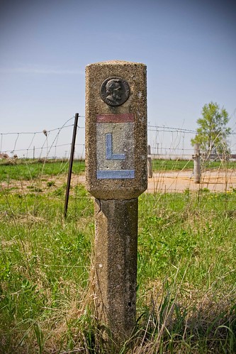
In 1928, one of the last updates to the original Lincoln Highway was made. In September of that year, groups of Boy Scouts set up over 2000 concrete markers along the highway. Featuring the red white and blue Lincoln Highway logo and a directional arrow, these markers were set up at minor intersections, as well as in more remote areas to help guide travelers and reassure them that they were on the right track.
Many of these old concrete markers are gone, but just outside the town of Franklin Grove, Illinois, four of them are still standing, all within the same mile of road. Three of them are still right next to the road (the fourth is well off the road, near an older alignment of the highway), and are still in decent shape (that fourth one is the worst, with a big chip out of it). In a nice bit of historical symmetry, Franklin Grove is the current headquarters of the Lincoln Highway Association, which is dedicated to preserving and promoting the history of this important road.
Friday, October 8, 2010
Coast to Coast
Subscribe to:
Post Comments (Atom)
No comments:
Post a Comment